


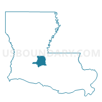
Precinct 5-1, St. Landry Parish, Louisiana
About
Outline

Summary
| Unique Area Identifier | 590634 |
| Name | Precinct 5-1 |
| County | St. Landry Parish |
| State | Louisiana |
| Area (square miles) | 48.73 |
| Land Area (square miles) | 48.40 |
| Water Area (square miles) | 0.33 |
| % of Land Area | 99.32 |
| % of Water Area | 0.68 |
| Latitude of the Internal Point | 30.69267560 |
| Longtitude of the Internal Point | -92.05010760 |
Maps


Graphs
Select a template below for downloading or customizing gragh for Precinct 5-1, St. Landry Parish, Louisiana


Neighbors
Neighoring Voting District (by Name) Neighboring Voting District on the Map
- Precinct 4-10, St. Landry Parish, LA
- Precinct 4-12A, St. Landry Parish, LA
- Precinct 4-4, St. Landry Parish, LA
- Precinct 4-8, St. Landry Parish, LA
- Precinct 5-2, St. Landry Parish, LA
- Precinct 5-4, St. Landry Parish, LA
- Precinct 5-5, St. Landry Parish, LA
- Precinct 5-6, St. Landry Parish, LA
- Precinct 5-8, St. Landry Parish, LA